In river water level monitoring, flood control and early warning, reservoir management, urban drainage monitoring, and smart water management projects, reliable and continuous water level measurement is one of the most important requirements for an effective monitoring system.
Unlike storage tanks, process vessels, or water pools located inside industrial plants, outdoor river monitoring points are often far away from power distribution facilities. Some monitoring locations may be installed on bridges, riverbanks, embankments, mountainous areas, or remote pumping stations.
If a separate power cable has to be laid only to operate a water level instrument, the installation cost can become relatively high. Long-distance cabling may require excavation, conduit installation, electrical distribution equipment, and additional protection measures. Cables installed near rivers may also be exposed to flooding, thunderstorms, construction activities, and environmental damage.
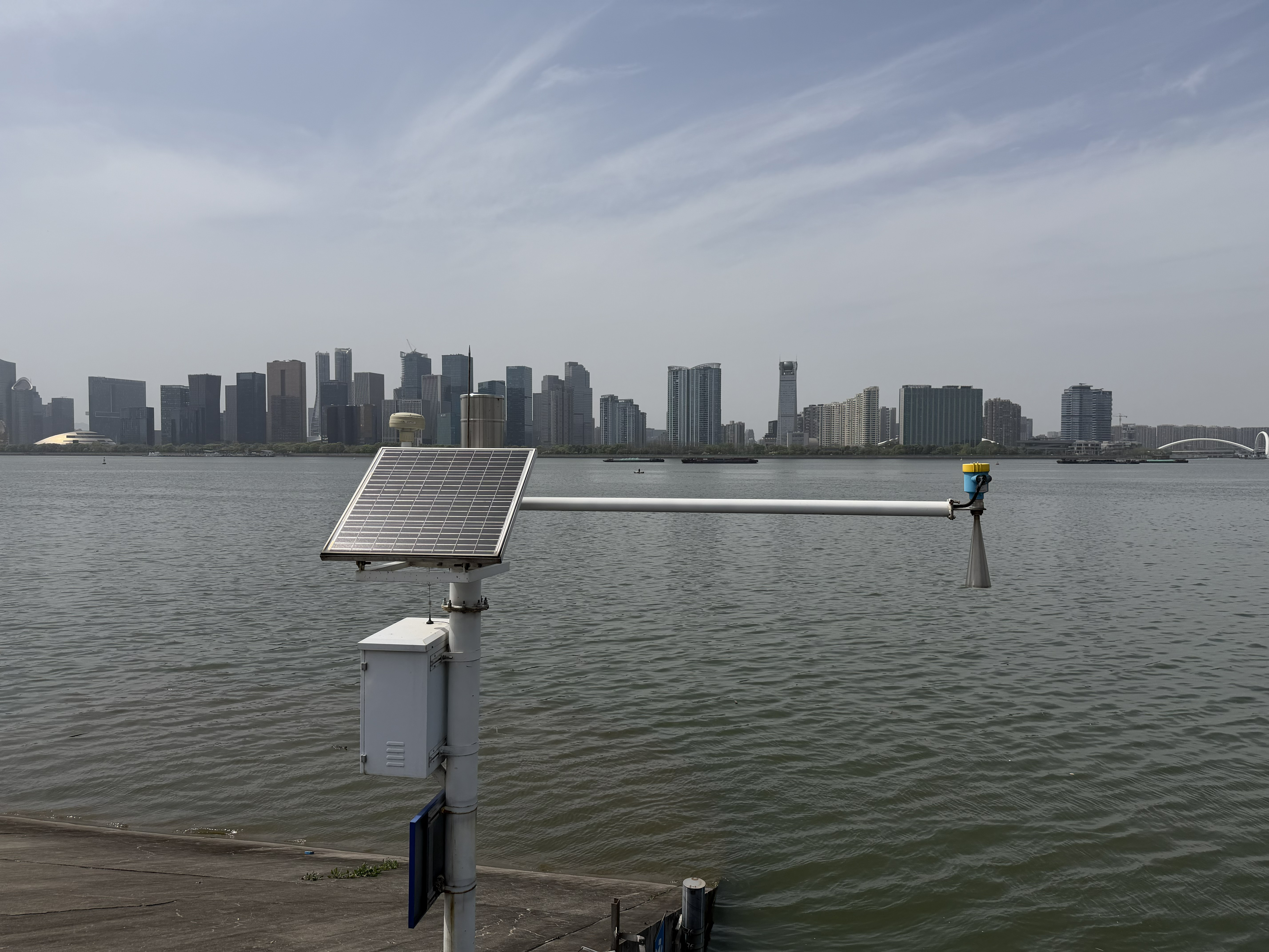
For these applications, a monitoring solution consisting of a JWrada-32 radar level meter, battery, solar panel, power management module, and data acquisition terminal can provide an independent outdoor river water level monitoring system.
During daylight hours, the solar panel charges the battery through a solar charge controller. The battery then supplies DC power to the radar level meter and communication equipment during the night, cloudy weather, or periods of low sunlight.
This configuration allows the monitoring station to operate independently of mains electricity while continuously measuring, recording, and transmitting river water level data.
1. Project Background: How Can River Water Level Be Monitored Without Mains Power?
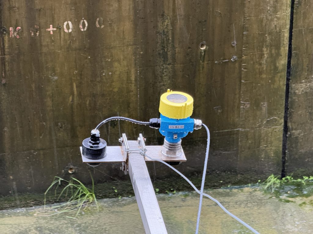
In a river water level monitoring project, the measurement point was located near an urban river and pumping station.
The monitoring system needed to continuously record changes in river water level so that the collected data could be used for flood control, pumping station operation, water management, and historical trend analysis.
However, several challenges were present at the site.
First, the monitoring location was relatively far from the existing electrical power network. Installing a new AC power supply would have required long-distance cable laying, excavation, conduit protection, and additional distribution equipment.
Second, the river monitoring point was located in a typical outdoor environment. During summer, the equipment was exposed to strong sunlight. During the rainy season, humidity was high and water mist was frequently present.
Heavy rainfall could also cause rapid changes in river flow and water level. Wind, rain, floating debris, and surface waves could further affect the water surface.
In addition, the monitoring station was expected to operate unattended for long periods. Instruments requiring frequent sensor cleaning, recalibration, or manual maintenance would significantly increase operating costs.
Therefore, the project needed to solve two important problems:
How can river water level be measured reliably, and how can the monitoring system operate continuously when no mains electricity is available?
Considering these site conditions, the project adopted a JWrada-32 radar level meter together with a solar panel, battery, and DC power management system.
2. Why Use a Radar Level Meter for River Water Level Measurement?
River water level measurement is a typical open-water level monitoring application.
Traditional contact-type level measurement technologies generally require the sensor to be in direct contact with the water. As a result, the sensor may be affected by sediment, floating debris, aquatic plants, or hydraulic impact during flooding.
Some ultrasonic level measurement systems also need to consider the influence of air temperature, water vapor, fog, and environmental conditions on sound wave transmission.
A radar level meter uses a non-contact measurement principle.
The instrument is installed above the water surface, which means that the sensor does not need to be submerged in the river.
The JWrada-32 uses 80 GHz FMCW radar technology.
The radar antenna transmits high-frequency electromagnetic waves toward the water surface. When the radar signal reaches the water surface, part of the signal is reflected back toward the instrument.
The radar level meter receives the reflected signal and calculates the distance between the radar reference point and the water surface.
By combining this distance measurement with the configured riverbed reference level, zero point, or elevation data, the monitoring system can calculate the actual water level.
The JWrada-32 offers a maximum measurement range of up to 60 meters and a stated measurement accuracy of up to ±1 mm.
Its narrow radar beam helps reduce interference from surrounding structures such as bridge components, guardrails, support frames, and other fixed objects.
This is particularly useful for river monitoring applications where the radar is installed on bridges, riverbanks, flood control platforms, or other elevated structures.
Another important advantage is the non-contact measurement method.
Since the radar level meter does not normally come into direct contact with river water, it is less likely to be affected by sediment, floating objects, or hydraulic impact.
This makes radar technology suitable for long-term and unattended river water level monitoring.
3. System Configuration of JWrada-32 with Solar Panel and Battery
To eliminate dependence on mains electricity, the project uses an independent DC power supply architecture.
The complete river water level monitoring system typically consists of the following components.
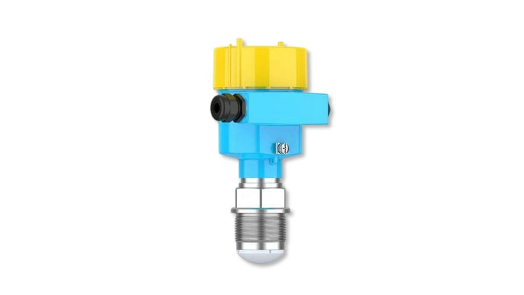
3.1 JWrada-32 Radar Level Meter
The JWrada-32 continuously measures the distance between the radar sensor and the water surface and converts the measurement into a water level signal.
The instrument supports a 12–30 V DC power supply, making it suitable for battery-powered and solar-powered monitoring systems.
Depending on the project configuration, the radar level meter can provide 4–20 mA/HART or RS485/Modbus signal output.
This allows it to communicate with PLCs, RTUs, data loggers, remote telemetry units, or wireless communication terminals.
3.2 Solar Panel
The solar panel provides the primary source of energy for the off-grid monitoring station.
When sufficient sunlight is available, the solar panel supplies energy through the charge controller and charges the battery.
The required solar panel capacity should not be selected only according to the power consumption of the radar level meter.
The total power consumption of the complete monitoring station should be considered, including the RTU, 4G or NB-IoT communication terminal, lightning protection equipment, and other auxiliary devices.
3.3 Battery
The battery stores energy generated by the solar panel.
It supplies power to the monitoring system during nighttime, cloudy weather, and periods of continuous rainfall.
Battery capacity should be selected according to several factors, including local solar radiation conditions, average system power consumption, data transmission frequency, and the required number of backup operating days.
A properly designed battery system should include sufficient reserve capacity rather than being sized only for minimum operation.
3.4 Solar Charge Controller and Power Management Module
The solar charge controller manages battery charging and protects the power system against overcharging, excessive discharge, and unstable voltage.
For unattended outdoor river monitoring stations, reliable power management is extremely important.
Even if the radar measurement itself is stable, repeated deep discharge of the battery may reduce the long-term reliability of the entire monitoring station.
3.5 Data Acquisition and Wireless Communication Terminal
The RTU or data acquisition unit receives the water level signal from the radar level meter through 4–20 mA or RS485/Modbus communication.
The measured data can then be transmitted through 4G, NB-IoT, or other wireless communication networks to a smart water management platform, flood monitoring system, or remote control center.
This enables operators to view real-time river levels and historical water level trends without visiting the site every day.
4. Can Radar Level Measurement Remain Stable When the River Surface Has Waves?
This is one of the most common questions in outdoor river level monitoring applications.
A natural river surface is not as stable as the liquid surface inside a storage tank.
Wind, rainfall, passing boats, rapid river flow, floating debris, and changing hydraulic conditions can all cause movement on the water surface.
Therefore, river water level measurement is not only about detecting the water surface.
The instrument must also continuously identify the true water surface echo while reducing the influence of interference signals.
The JWrada-32 uses 80 GHz high-frequency radar technology with a relatively narrow beam.
It also includes signal processing functions such as false echo identification, multiple echo processing, and dynamic target tracking.
When the instrument is installed correctly and configured properly, these functions help reduce interference caused by support structures, bridge components, and other fixed obstacles.
In open-water applications, radar technology can maintain continuous and stable water level measurement under conditions involving waves, high humidity, and water mist.
When combined with an independent solar power system, it can form a long-term unattended river monitoring station.
However, even a high-performance radar level meter requires proper installation.
If the radar antenna is pointed directly toward a bridge pier, metal guardrail, or another highly reflective structure, significant false echoes may still occur.
Therefore, installation design is just as important as instrument selection.
5. How Should the JWrada-32 Be Installed for River Water Level Monitoring?
For river water level measurement, the radar level meter can typically be installed beneath a bridge, on a riverbank support structure, on a pumping station platform, or on a dedicated mounting pole.
The radar antenna should point vertically toward the selected water surface measurement area.
Several installation recommendations should be considered.
5.1 Select a Relatively Stable Water Surface
Avoid installing the radar directly above a waterfall, drainage outlet, gate discharge area, or strong vortex.
Water surfaces in these locations may fluctuate excessively.
Although the radar may still be able to measure the surface, the resulting data may not accurately represent the actual water level of the river section being monitored.
5.2 Avoid Bridge Piers and Metal Structures
The radar beam should be kept as clear as possible from guardrails, beams, cables, bridge piers, and other fixed objects.
If installation space is limited, false echo suppression and parameter optimization can be used according to the actual echo profile.
5.3 Keep the Antenna Perpendicular to the Water Surface
The mounting bracket should have sufficient mechanical strength.
Movement caused by strong wind should be minimized because continuous vibration or movement of the instrument can affect measurement stability.
For installations using poles on riverbanks, the length of the horizontal arm, mounting method, and wind resistance should be carefully considered.
5.4 Provide Sun Protection for Outdoor Installation
The JWrada-32 offers an IP66/IP68 enclosure protection rating, making it suitable for outdoor operating conditions.
However, when the instrument is continuously exposed to strong direct sunlight, a sunshade is still recommended.
This can help reduce surface temperature and minimize the long-term effects of solar exposure on the instrument housing and display components.
5.5 Install Proper Lightning Protection and Grounding
Riverbanks, bridges, and open outdoor areas can be exposed to lightning.
The solar panel, power cables, communication lines, mounting structure, and instrumentation system should therefore be designed with appropriate lightning protection and grounding measures.
This is particularly important in regions with frequent thunderstorms.
A reliable river monitoring station requires protection of the complete system, not only the radar level meter itself.
6. How Should the Solar Panel and Battery Be Sized?
The reliability of a solar-powered river level monitoring system depends heavily on the design of the power supply.
A common mistake is to see that the radar level meter operates on 12–30 V DC and then simply select a small solar panel and battery.
In practice, the required power capacity should be calculated according to the total daily energy consumption of the complete monitoring station.
For example:
The radar level meter consumes electrical power.
The RTU requires electrical power.
The 4G or NB-IoT communication module consumes additional power, especially during data transmission.
The solar charge controller also introduces some energy loss.
Solar generation may also decrease during winter, cloudy periods, or continuous rainy weather.
Therefore, the first step should be to calculate the operating voltage, current consumption, and daily operating time of each device.
The total daily energy consumption can then be calculated.
The required solar panel capacity can be estimated according to the average effective sunlight hours available at the installation location.
Battery capacity should then be selected based on the required number of operating days without sufficient solar charging.
For projects that do not require second-by-second data transmission, overall energy consumption can also be reduced by optimizing the measurement interval and remote data upload frequency.
For remote river monitoring stations, optimizing total system power consumption can often be more valuable than simply installing a larger solar panel.
7. Commissioning the System: Confirm the Distance First, Then Calculate the Water Level
After installation, the relationship between radar measurement distance and actual river water level must be established.
For example, the distance between the radar reference point and a defined riverbed elevation may be fixed.
When the water level rises, the distance from the radar to the water surface becomes shorter.
When the water level falls, the measured distance becomes longer.
By configuring the zero point, measurement range, and elevation reference parameters, the distance measurement can be converted into the required water level value.
The JWrada-32 also supports Bluetooth wireless configuration.
This can be useful when the instrument is installed at a high position or in a location with limited access.
Maintenance personnel can adjust relevant parameters with less need for direct physical access to the radar level meter.
During initial commissioning, it is recommended to compare the radar reading with a manual water level gauge.
The measurement can be checked at low water level, normal water level, and after noticeable changes in river level.
This comparison helps confirm whether the installation reference point, zero setting, and measurement range have been configured correctly.
8. Practical Results After the System Was Put Into Operation
After the JWrada-32 radar level meter and solar power supply system were installed, the monitoring station no longer required a long-distance AC power cable.
This reduced installation complexity at the remote river monitoring point.
From the measurement perspective, the non-contact radar sensor is not directly exposed to sediment, floating debris, or hydraulic impact.
This helps reduce maintenance associated with contact-type sensors.
From the power supply perspective, the solar panel charges the battery during daylight hours, while the battery continues to supply power during the night and during low-light conditions.
This allows the water level monitoring system to operate continuously.
From the data management perspective, the radar level meter can be connected to an RTU and wireless communication terminal so that water level data can be continuously transmitted to a remote monitoring platform.
Operators can then view real-time values, historical trends, and changes in river level.
The collected data can support flood control, water management, pumping station operation, and abnormal water level alarms.
For projects requiring multiple river monitoring points, this type of independent monitoring node offers another important advantage.
Each location has its own measurement, power supply, and communication system.
The project does not need to depend on a single long-distance power network connecting all monitoring points.
When additional monitoring stations are required, new nodes can be deployed as long as suitable mounting conditions, solar exposure, and wireless network coverage are available.
9. Which Water Level Monitoring Applications Are Suitable for This Solution?
A JWrada-32 radar level meter combined with a solar panel and battery is not limited to ordinary river monitoring.
A similar configuration can be used for:
River and urban waterway level monitoring, flash flood warning stations, reservoir water level monitoring, irrigation canal monitoring, drainage channel monitoring, bridge-based water level monitoring, pumping station forebay measurement, collection wells, and other outdoor level measurement applications where mains electricity is difficult to access.
This solution is especially suitable for projects where monitoring points are widely distributed, located far from existing electrical infrastructure, and required to operate automatically for long periods.
The combination of non-contact radar measurement and independent solar power can provide a practical solution for remote water level monitoring.
10. Frequently Asked Questions About Solar-Powered Radar River Level Monitoring
Can the Radar Level Meter Be Powered Directly by a Battery?
The JWrada-32 operates on 12–30 V DC, so it can be integrated with a compatible battery-based DC power supply.
However, in practical projects, a complete outdoor power system should normally include a solar charge controller, voltage protection, lightning protection, and suitable power management equipment.
Will the System Stop Working During Several Days of Rain?
Whether the system can continue operating depends on battery capacity, total power consumption, and the backup period considered during system design.
The solar power system should be sized according to local weather and solar conditions rather than only according to energy generation on sunny days.
Can a Radar Level Meter Work When There Are Waves on the River?
Yes.
However, the installation point should be selected carefully.
The radar should not be positioned directly above waterfalls, drainage outlets, or strong vortices.
Proper mounting, echo recognition, and parameter configuration can help improve measurement stability under dynamic water surface conditions.
Why Is Non-Contact Radar Increasingly Used for Outdoor Water Level Monitoring?
One major reason is that the radar sensor does not need to come into direct contact with the river water.
This helps reduce the influence of sediment, floating debris, and flood impact.
Radar level meters can also be conveniently installed on bridges, riverbank supports, and monitoring platforms, making them suitable for integration with solar power systems and wireless communication equipment.
Conclusion
For rivers, drainage channels, and remote hydrological monitoring stations without reliable mains electricity, water level measurement is not simply a matter of selecting an instrument.
A complete monitoring system must also consider measurement stability, power supply, wireless communication, outdoor protection, installation conditions, and long-term maintenance requirements.
The JWrada-32 radar level meter uses 80 GHz FMCW non-contact radar technology, supports a 12–30 V DC power supply, and provides multiple industrial communication outputs.
When combined with a solar panel, battery, power management module, and wireless RTU, it can form an independent outdoor river water level monitoring station.
This configuration reduces dependence on long-distance electrical cabling while taking advantage of non-contact radar measurement, relatively low maintenance requirements, and convenient remote data acquisition.
From a single river monitoring station to a network of multiple hydrological monitoring points, the JWrada-32 radar level meter with solar power supply provides a practical technical solution for river water level monitoring, flood control, and smart water management projects.